Map Sheet Indexes and Coordinate Systems
Map sheets are oriented in relation to the central meridian, the x-coordinate increases towards the north and the y-coordinate towards the east.
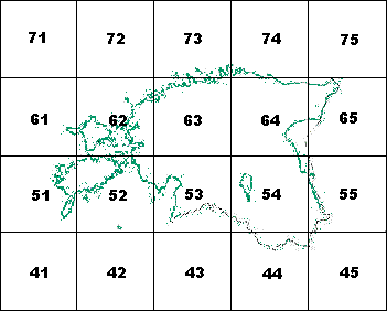
The sheet line system is based on the map sheet index at 1:200 000.

1:20 000 and 1:10 000 Map Sheets
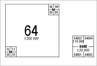
The Estonian Basic Map is divided into 50x50 cm map sheets. At the scale of 1:10 000 the map sheet covers an area of 5x5 km, at the scale of 1:20 000 the area is 10x10 km.
By dividing the 1:200 000 map sheet into 100 smaller squares (numeration starting from the left bottom) we get a 1:20 000 Basic Map sheet.
The number of 1:20 000 Basic Map has four digits and consists of two parts:
- 1:200 000 sheet number
- 1:20 000 sheet number(00-99)
A dot is used between the two numbers, e.g.64.10

By dividing the 1:20 000 map sheet into four (numeration starting again from the left bottom) we get a 1:10 000 map sheet, the number of which has 5 digits (e.g.64.103) and consists of the following parts:
- 1:200 000 sheet number
- 1:20 000 sheet number(00-99)
- 1:10 000 sheet number(1-4
1:100 000 and 1:50 000 Map Sheets
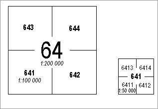
The 1:200 000 sheet is divided into four, the outcome being 1:100 000 sheet number which has three digits (e.g.641).
The 1:100 000 sheet is divided into four, which results in 1:50 000 map sheet number that has four digits (e.g. 6411).

The Estonian Topographic Map 1:50 000 is divided into 50x50 cm map sheets. At the scale of 1:50 000 the map sheet covers an area of 25x25 km.
Unlike the 1:20 000 map sheet index the numbers are not separated by a dot.
1:2000 Map Sheets
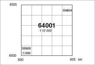
1:2000 map sheets are also 50x50 cm squares that cover the area of 1x1 km.

To assign a number to the plan, the 1:10 000 sheet is divided into 25 sheets. The plan number has 6 digits and is formed of the rectangular coordinates of the left bottom corner of the sheet (e.g.504604), in the first place there are three last x-coordinates and in the second place the y-coordinate in kilometers.